
Page 3 - TR Spirit of Batesville May 2016
P. 3
THREE RIVERS EDITION OF THE ARKANSAS DEMOCRATGAZETTE • SPIRIT OF BATESVILLE SUNDAY, MAY 15, 2016 3SS
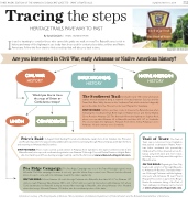
Tracing the steps HERITAGE TRAILS PAVE WAY TO PAST
By Sarah DeClerk | SPECIAL SECTIONS WRITER
It can be haunting to consider those who carved the paths we walk on now.The Batesville area is rich in history, and many of the highways in use today have been used for centuries by settlers, soldiers and Native Americans. Follow this flow chart to find a road trip that will take you back in time.
WILLIAM HARVEY/THREE RIVERS EDITION
Are you interested in Civil War, early Arkansas or Native American history?
CIVIL WAR HISTORY
Would you like to trace the steps of Union or Confederate troops?
CONFEDERATE
EARLY ARKANSAS HISTORY
NATIVE AMERICAN HISTORY
T h e S o u t h w e s t Tr a i l : D u r i n g t h e e a r l y 1 9 t h c e n t u r y, E u r o p e a n settlers moved westward along a network of routes between St. Louis and the Texas Red River Valley known as the Southwest Trail, which stretched diagonally across the state from the Missouri border near Maynard toTexarkana.
ONTHE ROAD: Settlers used two routes to traverse the Batesville area when following the Southwest Trail. Both begin in Walnut Grove and follow Walnut Grove Road to Arkansas 233.The first trek follows the highway to Sulphur Rock, where one can take Arkansas 69 to Batesville, and then U.S. 167 to Southside. The second takes the highway to Newark. From there, follow Arkansas 122 to Arkansas 14, and continue on to Southside.
UNION
Price’s Raid: In August 1864, Sterling Price led a Confederate cavalry force from Camden into Princeton and Pocahontas, where he was joined by additional troops before journeying through Missouri, Kansas and IndianTerritory
and returning to Arkansas that December.
ON THE ROAD: Price’s route covered a wide stretch of Arkansas from Camden to the state’s northern border. In the Batesville area, his troops rode northeast along what is now Arkansas 25 through Concord, Desha, Dennison Heights, Bates- ville, Cord and beyond.Those desiring a longer road trip can find the full route at www.arkansasheritagetrails.com.
Pea Ridge Campaign: The Pea Ridge Campaign was one of the Trans-Mississippi region’s most influential Civil War campaigns because it not only gave the Union Army control over Missouri, but also allowed Union troops to cut a path into Arkansas, toward the state’s capital city.
ON THE ROAD: Follow Arkansas 69 south through Cushman into Batesville; then take U.S. 67 to Arkansas 157 until you reach Plainview.Take Arkansas 385 to U.S. 167/67 until you reach its intersection with Arkansas 367, where Curtis backtracked to Batesville during a retreat. After returning to Batesville, drive along Arkansas 69 to Newark, where the troops followed Arkansas 122 farther into the northeast portion of the state.
Trail of Tears: The Trail of Tears was a notorious forced migration that pushed southeastern Native Amer- ican tribes westward into present-day Oklahoma.The tribes traveled across Ar- kansas using both land and river routes, including a route that passed through the Batesville area.
ONTHE ROAD: Beginning in Cave City, head south on U.S. 167 through Batesville to Arkansas 69 Business.Then take Arkan- sas 69 through Cushman until the highway intersects with Arkansas 58 near Mount Pleasant.This section is part of the Benge Route. An extensive listing of the Trail of Tears pathways in Arkansas can be found at www.arkansasheritagetrails.com.
Information courtesy of The Encyclopedia of Arkansas History & Culture, the Arkansas Department of Parks & Tourism and the Batesville Area Chamber of Commerce.
